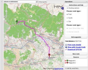
OSRM è un velocissimo motore di routing open source per dati OpenStreetmap, in questo breve articolo vengono descritte alcune delle sue caratteristiche più importanti.
Questo articolo è disponibile solo in inglese, puoi cambiare la lingua usando i collegamenti in cima alla pagina.
The routing engine
Recently we have upgraded our multi-site Django-based platform (see: MapSlow) to support OpenStreetMap routing with OSRM. OSRM is a lightning fast routing server that uses OpenStreetMap data to calculate routes based on different routing profiles, the system is very flexible and configurable, you can setup profiles for car, foot, and bicycle and decide every detail about where the different users (pedestrian, cyclists etc.) can pass trough or cross.
The process of preparing OSM data for routing requires high CPU and RAM resources and quite a lot of time, we are using a 16 cores and 32 GB RAM virtual instance and the full update takes about 90′ for each profile (for Italy only!!), of course we are running this process (weekly) in the background, at night while server load is typically low.
Since we are using three different profiles, we need three independant OSRM server instances, each running instance requires a huge amount or RAM, for this reason we chose such a powerful server.
We are really satisfied with OSRM, the performances are very good and response is ligthning fast, allowing for a richful UX: while the user drags a waypoint the routes are immediately updated on the screen.
The only missing piece is the ability to use altitude data, this can be a problem when calculating routes for bicycle and foot profiles because they should really take altitude into account to calculate the shortest paths in terms of time.


David Williams
OSRM is built on openlayers and the OSRM web server is opengeo.org?
Alessandro Pasotti
@David,
no, OSRM is a stand-alone server-side platform.
We are using GeoEXT for the client side, GeoEXT is based on Ext and OpenLayers.
Map Not Working
your map site does not work, I only see the app borders and controls, but a white background where the map should be and the “please wait” icon never disappears.
Alessandro Pasotti
Works for me: tested with MSIE 8 and MSIE 9 Firefox and Chrome.
What browser version and OS are you using?