 Whatever is your level of Python knowledge, when you’ll discover the advantages and super-powe...
  Whatever is your level of Python knowledge, when you’ll discover the advantages and super-powe...
  Whatever is your level of Python knowledge, when you’ll discover the advantages and super-powe...
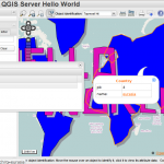
  How to easily add some STYLE to your QGIS Server WMS GetFeatureInfo response by using the new Py...
  In this article I describe step by step how to setup QGIS Server Python Plugins on a fresh Ubuntu se...
  Python plugins for QGIS server tutorial
...
  Python plugins support for QGIS server was finally merged and brings a full set of amazing possibili...
  Time for something new: recently I've been busy with the implementation of QGIS Server Python Plug...
  Either you are using the search panels or you are using the "identify" feature of QGIS Web C...
  We actively contribute to QGIS project developing python plugins and the QGIS Web Client. We als...
  This is the second part (read the first part) of my GDAL geocoding experiments, here I’m tryin...
  GDAL library has an API which provides geocoding capabilities using webservices, supported providers...