Main configuration
GeoContent Plus main configuration is done through the “Options” button in the main GeoContent Plus view (from Joomla! control panel, choose Components‣GeoContent then click on the “Options” icon on the right).
GeoContent Plus is configured through Parameters.
All parameters can be set in the globalconfiguration window, most of them can be overridden in the individual Overview maps menu item configuration (see: Overview maps configuration), only a selected set of parameters can be set in Tag maps.
There are three places where parameters can be set:
When Front-end editing is enabled (see Front-end map edit parameters below), the editor map window can also be configured through key-value-pairs in the hyperlink as explained in Front-end configuration.
Note
Not all parameters are supported in the three methods, see the full parameters list below.
See also
GeoContent Plus main configuration is done through the “Options” button in the main GeoContent Plus view (from Joomla! control panel, choose Components‣GeoContent then click on the “Options” icon on the right).
This section contains a detailed list of all configuration parameters and their meaning.
This parameters are available in globalconfiguration window, the windows consists of different panels.
Default map zoom level and center
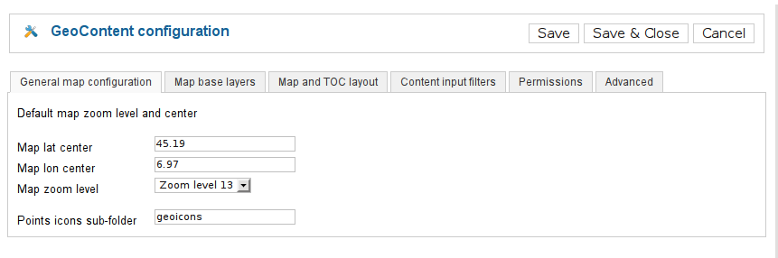
Default map zoom level and center
| Label | Name | Type | Description |
|---|---|---|---|
| Map lat center | map_latstart | text | Insert here the latitude for the map at start, leave blank for default value. |
| Map lon center | map_lngstart | text | Insert here the longitude for the map at start, leave blank for default value. |
| Map zoom level | map_zoomstart | list | Insert here the initial zoom level for the map at start - Accepted values: 0 (Zoom level 0), 1 (Zoom level 1), 2 (Zoom level 2), 3 (Zoom level 3), 4 (Zoom level 4), 5 (Zoom level 5), 6 (Zoom level 6), 7 (Zoom level 7), 8 (Zoom level 8), 0 (Zoom level 9), 10 (Zoom level 10), 11 (Zoom level 11), 12 (Zoom level 12), 13 (Zoom level 13), 14 (Zoom level 14), 15 (Zoom level 15), 16 (Zoom level 16), 17 (Zoom level 17), 18 (Zoom level 18), 19 (Zoom level 19), 20 (Zoom level 20) |
| Points icons sub-folder | point_icon_folder | text | Insert here the subdirectory of ‘images’ folder for the point icons. Leave it blank to use the standard Joomla ‘images’ folder. |
Maps base layers configuration. Options marked with ‘OL only’ are only available for OpenLayers based maps.
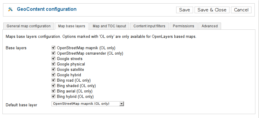
Maps base layers configuration. Options marked with ‘OL only’ are only available for OpenLayers based maps.
| Label | Name | Type | Description |
|---|---|---|---|
| Base layers | base_layers | checkboxes | Select the base layers to use in OpenLayers maps. The default base layer is selected automatically. - Accepted values: osm.mapnik (OpenStreetMap mapnik (OL only)), osm.cyclemap (OpenStreetMap CycleMap (OL only)), osm.transportmap (OpenStreetMap TransportMap (OL only)), google.streets (Google streets), google.physical (Google physical), google.satellite (Google satellite), google.hybrid (Google hybrid), ve.road (Bing road (OL only)), ve.aerial (Bing aerial (OL only)), ve.hybrid (Bing hybrid (OL only)) |
| Default base layer | default_base_layer | list | The base layer active at start, will be automatically added to the base layers list. - Accepted values: osm.mapnik (OpenStreetMap mapnik (OL only)), osm.cyclemap (OpenStreetMap CycleMap (OL only)), osm.transportmap (OpenStreetMap TransportMap (OL only)), google.streets (Google streets), google.physical (Google physical), google.satellite (Google satellite), google.hybrid (Google hybrid) |
OpenLayers based maps support Bing layers. Before using this layers you must obtain an API key at (http://bingmapsportal.com/).
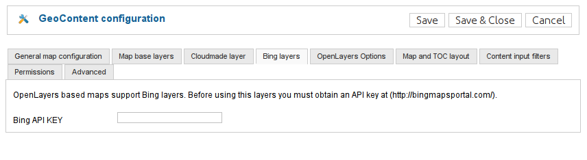
OpenLayers based maps support Bing layers. Before using this layers you must obtain an API key at (http://bingmapsportal.com/).
| Label | Name | Type | Description |
|---|---|---|---|
| Bing API KEY | bing_api | text | Get one at http://bingmapsportal.com/ |
OpenLayers based maps support Google layers. Before using this layers you must obtain an API key at (https://developers.google.com/maps/documentation/javascript/get-api-key).
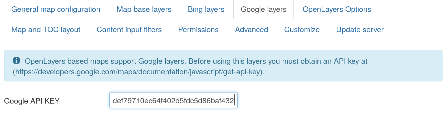
OpenLayers based maps support Google layers. Before using this layers you must obtain an API key at (https://developers.google.com/maps/documentation/javascript/get-api-key).
| Label | Name | Type | Description |
|---|---|---|---|
| Google API KEY | google_api | text | Get one at https://developers.google.com/maps/documentation/javascript/get-api-key |
For OpenLayers based maps you can set some specific options
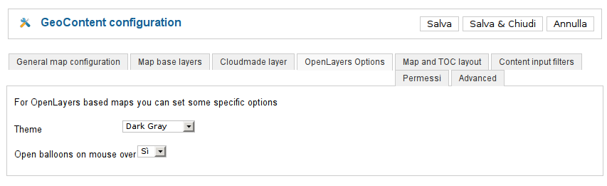
For OpenLayers based maps you can set some specific options
| Label | Name | Type | Description |
|---|---|---|---|
| Theme | ol_custom_theme | list | The theme defines icons colors for the map user interface - Accepted values: img (Default (blue)), img.dark_grey (Dark Gray), img.black_grey (Gray 2) |
| Open balloons on mouse over | balloon_onmouseover | list | OpenLayers maps can open balloons on mouse over instead of on mouse click (default) - Accepted values: 1 (Yes), 0 (No) |
Define the map layout of the public site
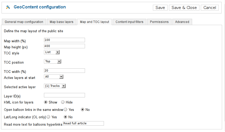
Define the map layout of the public site
| Label | Name | Type | Description |
|---|---|---|---|
| Map width (%) | map_width | text | The width of the map wrapper DIV in percent |
| Map height (px) | map_height | text | The height of the map wrapper DIV in pixels |
| TOC style | toc_style | list | Style of the Table of Content - Accepted values: none (JNOne), list (List), select (Select) |
| TOC position | toc_position | list | TOC position with respect to the map window within the map wrapper DIV - Accepted values: top (Top), bottom (Bottom), left (Left), right (Right) |
| TOC width (%) | toc_width | text | The width of the TOC frame when it is positioned at the left or at the right of the map frame |
| Active layers at start | start_with_layers | list | Define here which layer should be switched on at startup, choose ‘Selected’ and pick one from the list below if you want to start with a particular layer - Accepted values: none (none), all (All), one (Selected) |
| Layer ID(s) | layer_filter_list | text | Optionally, enter here a comma separated value list of the layer ID(s) you want to be shown in the map |
| KML icon for layers | toc_kml | radio | Show a link to the KML file for the layers close to the layer control switch in the TOC - Accepted values: 1 (Show), 0 (Hide) |
| Open balloon links in the same window | replace_target | radio | Replace target = _blank in the map balloon links, so that they are opened in the same window - Accepted values: 1 (Yes), 0 (No) |
| Lat/Long indicator (OL only) | show_mouse_position | list | Shows Lat/Long indicator in top right corner of the map window (OL only) - Accepted values: 1 (Yes), 0 (No) |
| Read more text for balloons hyperlinks | readmore | text | Enter the text for the read more hyperlink in balloons |
Location and position services
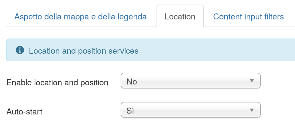
Location and position services
| Label | Name | Type | Description |
|---|---|---|---|
| Enable location and position | location_enabled | list | A button and a ccheckbox will be shown above the map to control location and position services - Accepted values: 1 (Yes), 0 (No) |
| Auto-start | location_on_by_default | list | Automatically activate position service at start - Accepted values: 1 (Yes), 0 (No) |
GeoContent internals configuration, experts only. Options marked with ‘OL only’ are only available for OpenLayers based maps.
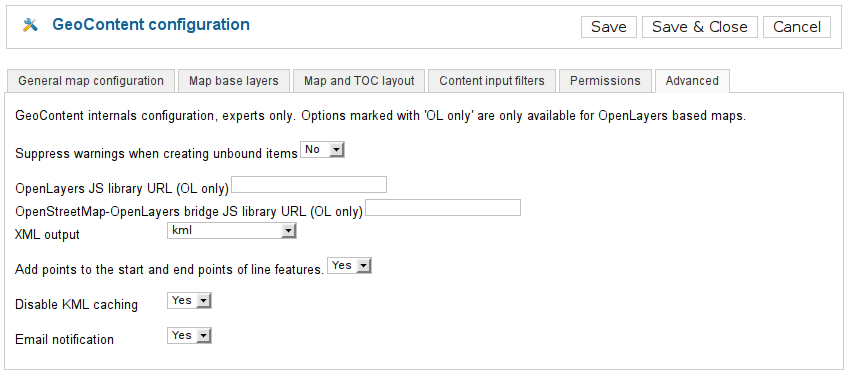
GeoContent internals configuration, experts only. Options marked with ‘OL only’ are only available for OpenLayers based maps.
| Label | Name | Type | Description |
|---|---|---|---|
| Suppress warnings when creating unbound items | suppress_unbound_warning | list | Suppress the warning message issued when the user tries to create an unbound item. - Accepted values: 1 (Yes), 0 (No) |
| OpenLayers JS library URL (OL only) | ol_url | text | The URL for the OpenLayers JS library (OL only), leave it blank to use the OpenLayers library provided with GeoContent (which is the only supported version) |
| OpenStreetMap-OpenLayers bridge JS library URL (OL only) | ol_osm_url | text | The URL for the OpenStreetMap-OpenLayers bridge JS library (OL only), leave it blank to use the library provided with GeoContent (which is the only supported version) |
| XML output | kml_type | list | Choose normal or compressed output, leave to KML when debugging. KMZ is fine for production. This options has no effect on OpenLayers based maps. - Accepted values: kml (kml), kmz (kmz (compressed)) |
| Add points to the start and end points of line features. | kml_add_point | list | Sometimes can be difficult to click on a line feature to open the balloon, by adding a point (and an icon) to the beginning and end of line the users can also click on the icons instead of clicking on the line. - Accepted values: 1 (Yes), 0 (No) |
| Disable KML caching | kml_no_cache | list | This has only effect on Google Maps, better leave to NO when in production. - Accepted values: 1 (Yes), 0 (No) |
| Email notification | warn_admins | list | Sends an email notification to admins when a new GeoContent item is added in front-end. - Accepted values: 1 (Yes), 0 (No) |
Look and feel customization with personal CSS
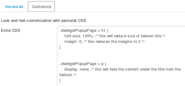
Look and feel customization with personal CSS
| Label | Name | Type | Description |
|---|---|---|---|
| Extra CSS | custom_style | textarea | This CSS will be automatically injected into the page containing a GeoContent map. |
The update server provides automatic updates through Joomla! updater component. If you have purchased this component, please enter the update server key (usually this is the PayPal transaction ID). This will give you access to automatic updates for 12 months from the purchase. Of course this field can be left blank in case of free versions.
| Label | Name | Type | Description |
|---|---|---|---|
| Update server key | itopen_update_server_key | text | If you have purchased this component, please enter the update server key (usually this is the PayPal transaction ID). This will give you access to automatic updates for 12 months from the purchase. Of course this field can be left blank in case of free versions. |
This group of options affects the appearance of the map, its size, the presence and position of the Table of Contents and which layers are visible and automatically activated when the map is loaded. All of this options are also available in Tag maps.
Different Map renderers have slightly different configuration parameters.
| Label | Name | Type | Description |
|---|---|---|---|
| Map lat center | map_latstart | text | Insert here the latitude for the map window start |
| Map lon center | map_lngstart | text | Insert here the longiture for the map window start |
| Map zoom level | map_zoomstart | list | Insert here the initial zoom level for the map window start - Accepted values: 0 (Zoom level 0), 1 (Zoom level 1), 2 (Zoom level 2), 3 (Zoom level 3), 4 (Zoom level 4), 5 (Zoom level 5), 6 (Zoom level 6), 7 (Zoom level 7), 8 (Zoom level 8), 9 (Zoom level 9), 10 (Zoom level 10), 11 (Zoom level 11), 12 (Zoom level 12), 13 (Zoom level 13), 14 (Zoom level 14), 15 (Zoom level 15), 16 (Zoom level 16), 17 (Zoom level 17), 18 (Zoom level 18), 19 (Zoom level 19), 20 (Zoom level 20) |
Define the map layout of the public site
| Label | Name | Type | Description |
|---|---|---|---|
| Map width (%) | map_width | text | The width of the map wrapper DIV in percent |
| Map height (px) | map_height | text | The height of the map wrapper DIV in pixels |
| TOC style | toc_style | list | Style of the Table of Content - Accepted values: none (JNOne), list (List), select (Select) |
| TOC position | toc_position | list | TOC position in respect to the map window within the map wrapper DIV - Accepted values: top (Top), bottom (Bottom), left (Left), right (Right) |
| TOC width (%) | toc_width | text | The width of the TOC frame when it is positioned at the left or at the right of the map frame |
| Active layers at start | start_with_layers | list | Define here which layer should be switched on at startup, choose ‘Selected’ and pick one from the list below if you want to start with a particular layer - Accepted values: none (none), all (All), one (Selected) |
| Layer ID(s) | layer_filter_list | text | Optionally, enter here a comma separated value list of the layer ID(s) you want to be shown in the map |
| KML icon for layers | toc_kml | radio | Show a link to the KML file for the layers close to the layer control switch in the TOC - Accepted values: 1 (Show), 0 (Hide) |
| Open balloon links in the same window | replace_target | radio | Replace target = _blank in the map balloon links, so that they are opened in the same window - Accepted values: 1 (Yes), 0 (No) |
| Read more text for balloons hyperlinks | readmore | text | Enter the text for the read more hyperlink in balloons |
Maps base layers configuration. Options marked with ‘OL only’ are only available for OpenLayers based maps.
| Label | Name | Type | Description |
|---|---|---|---|
| Base layers | base_layers | checkboxes | Select the base layers to use in OpenLayers maps. The default base layer is selected automatically. - Accepted values: google.streets (Google streets), google.physical (Google physical), google.satellite (Google satellite), google.hybrid (Google hybrid) |
| Default base layer | default_base_layer | list | The base layer active at start, will be automatically added to the base layers list. - Accepted values: google.streets (Google streets), google.physical (Google physical), google.satellite (Google satellite), google.hybrid (Google hybrid) |
Location and position services
Location and position services
| Label | Name | Type | Description |
|---|---|---|---|
| Enable location and position | location_enabled | list | A button and a ccheckbox will be shown above the map to control location and position services - Accepted values: 1 (Yes), 0 (No) |
| Auto-start | location_on_by_default | list | Automatically activate position service at start - Accepted values: 1 (Yes), 0 (No) |
| Label | Name | Type | Description |
|---|---|---|---|
| Map lat center | map_latstart | text | Insert here the latitude for the map window start |
| Map lon center | map_lngstart | text | Insert here the longiture for the map window start |
| Map zoom level | map_zoomstart | list | Insert here the initial zoom level for the map window start - Accepted values: 0 (Zoom level 0), 1 (Zoom level 1), 2 (Zoom level 2), 3 (Zoom level 3), 4 (Zoom level 4), 5 (Zoom level 5), 6 (Zoom level 6), 7 (Zoom level 7), 8 (Zoom level 8), 9 (Zoom level 9), 10 (Zoom level 10), 11 (Zoom level 11), 12 (Zoom level 12), 13 (Zoom level 13), 14 (Zoom level 14), 15 (Zoom level 15), 16 (Zoom level 16), 17 (Zoom level 17), 18 (Zoom level 18), 19 (Zoom level 19), 20 (Zoom level 20) |
Define the map layout of the public site
| Label | Name | Type | Description |
|---|---|---|---|
| Map width (%) | map_width | text | The width of the map wrapper DIV in percent |
| Map height (px) | map_height | text | The height of the map wrapper DIV in pixels |
| TOC style | toc_style | list | Style of the Table of Content - Accepted values: none (JNOne), list (List), select (Select) |
| TOC position | toc_position | list | TOC position in respect to the map window within the map wrapper DIV - Accepted values: top (Top), bottom (Bottom), left (Left), right (Right) |
| TOC width (%) | toc_width | text | The width of the TOC frame when it is positioned at the left or at the right of the map frame |
| Active layers at start | start_with_layers | list | Define here which layer should be switched on at startup, choose ‘Selected’ and pick one from the list below if you want to start with a particular layer - Accepted values: none (none), all (All), one (Selected) |
| Layer ID(s) | layer_filter_list | text | Optionally, enter here a comma separated value list of the layer ID(s) you want to be shown in the map |
| KML icon for layers | toc_kml | radio | Show a link to the KML file for the layers close to the layer control switch in the TOC - Accepted values: 1 (Show), 0 (Hide) |
| Open balloon links in the same window | replace_target | radio | Replace target = _blank in the map balloon links, so that they are opened in the same window - Accepted values: 1 (Yes), 0 (No) |
| Read more text for balloons hyperlinks | readmore | text | Enter the text for the read more hyperlink in balloons |
Maps base layers configuration. Options marked with ‘OL only’ are only available for OpenLayers based maps.
| Label | Name | Type | Description |
|---|---|---|---|
| Base layers | base_layers | checkboxes | Select the base layers to use in OpenLayers maps. The default base layer is selected automatically. - Accepted values: osm.mapnik (OpenStreetMap mapnik (OL only)), osm.cyclemap (OpenStreetMap CycleMap (OL only)), osm.transportmap (OpenStreetMap TransportMap (OL only)), osm.hikebike (HikeBikeMap (OL only)), osm.hillshading (HikeBikeMap Hillshading (OL only)), google.streets (Google streets), google.physical (Google physical), google.satellite (Google satellite), google.hybrid (Google hybrid), ve.road (Bing road (OL only)), ve.aerial (Bing aerial (OL only)), ve.hybrid (Bing hybrid (OL only)) |
| Default base layer | default_base_layer | list | The base layer active at start, will be automatically added to the base layers list. - Accepted values: osm.mapnik (OpenStreetMap mapnik (OL only)), osm.cyclemap (OpenStreetMap CycleMap (OL only)), osm.transportmap (OpenStreetMap TransportMap (OL only)), osm.hikebike (HikeBikeMap (OL only)), osm.hillshading (HikeBikeMap Hillshading (OL only)), google.streets (Google streets), google.physical (Google physical), google.satellite (Google satellite), google.hybrid (Google hybrid) |
Location and position services
Location and position services
| Label | Name | Type | Description |
|---|---|---|---|
| Enable location and position | location_enabled | list | A button and a ccheckbox will be shown above the map to control location and position services - Accepted values: 1 (Yes), 0 (No) |
| Auto-start | location_on_by_default | list | Automatically activate position service at start - Accepted values: 1 (Yes), 0 (No) |
| Label | Name | Type | Description |
|---|---|---|---|
| Map lat center | map_latstart | text | Insert here the latitude for the map window start |
| Map lon center | map_lngstart | text | Insert here the longiture for the map window start |
| Map zoom level | map_zoomstart | list | Insert here the initial zoom level for the map window start - Accepted values: 0 (Zoom level 0), 1 (Zoom level 1), 2 (Zoom level 2), 3 (Zoom level 3), 4 (Zoom level 4), 5 (Zoom level 5), 6 (Zoom level 6), 7 (Zoom level 7), 8 (Zoom level 8), 9 (Zoom level 9), 10 (Zoom level 10), 11 (Zoom level 11), 12 (Zoom level 12), 13 (Zoom level 13), 14 (Zoom level 14), 15 (Zoom level 15), 16 (Zoom level 16), 17 (Zoom level 17), 18 (Zoom level 18), 19 (Zoom level 19), 20 (Zoom level 20) |
Define the map layout of the public site
| Label | Name | Type | Description |
|---|---|---|---|
| Map width (%) | map_width | text | The width of the map wrapper DIV in percent |
| Map height (px) | map_height | text | The height of the map wrapper DIV in pixels |
| TOC style | toc_style | list | Style of the Table of Content - Accepted values: none (JNOne), list (List), select (Select) |
| TOC position | toc_position | list | TOC position in respect to the map window within the map wrapper DIV - Accepted values: top (Top), bottom (Bottom), left (Left), right (Right) |
| TOC width (%) | toc_width | text | The width of the TOC frame when it is positioned at the left or at the right of the map frame |
| Active layers at start | start_with_layers | list | Define here which layer should be switched on at startup, choose ‘Selected’ and pick one from the list below if you want to start with a particular layer - Accepted values: none (none), all (All), one (Selected) |
| Layer ID(s) | layer_filter_list | text | Optionally, enter here a comma separated value list of the layer ID(s) you want to be shown in the map |
| KML icon for layers | toc_kml | radio | Show a link to the KML file for the layers close to the layer control switch in the TOC - Accepted values: 1 (Show), 0 (Hide) |
| Open balloon links in the same window | replace_target | radio | Replace target = _blank in the map balloon links, so that they are opened in the same window - Accepted values: 1 (Yes), 0 (No) |
| Read more text for balloons hyperlinks | readmore | text | Enter the text for the read more hyperlink in balloons |
| Open balloons on mouse over | balloon_onmouseover | list | OpenLayers maps can open balloons on mouse over instead of on mouse click (default) - Accepted values: 1 (Yes), 0 (No) |
Maps base layers configuration. Options marked with ‘OL only’ are only available for OpenLayers based maps.
| Label | Name | Type | Description |
|---|---|---|---|
| Base layers | base_layers | checkboxes | Select the base layers to use in OpenLayers maps. The default base layer is selected automatically. - Accepted values: osm.mapnik (OpenStreetMap mapnik (OL only)), osm.cyclemap (OpenStreetMap CycleMap (OL only)), osm.transportmap (OpenStreetMap TransportMap (OL only)), osm.hikebike (HikeBikeMap (OL only)), osm.hillshading (HikeBikeMap Hillshading (OL only)), google.streets (Google streets), google.physical (Google physical), google.satellite (Google satellite), google.hybrid (Google hybrid), ve.road (Bing road (OL only)), ve.aerial (Bing aerial (OL only)), ve.hybrid (Bing hybrid (OL only)) |
| Default base layer | default_base_layer | list | The base layer active at start, will be automatically added to the base layers list. - Accepted values: osm.mapnik (OpenStreetMap mapnik (OL only)), osm.cyclemap (OpenStreetMap CycleMap (OL only)), osm.transportmap (OpenStreetMap TransportMap (OL only)), osm.hikebike (HikeBikeMap (OL only)), osm.hillshading (HikeBikeMap Hillshading (OL only)), google.streets (Google streets), google.physical (Google physical), google.satellite (Google satellite), google.hybrid (Google hybrid) |
Location and position services
Location and position services
| Label | Name | Type | Description |
|---|---|---|---|
| Enable location and position | location_enabled | list | A button and a ccheckbox will be shown above the map to control location and position services - Accepted values: 1 (Yes), 0 (No) |
| Auto-start | location_on_by_default | list | Automatically activate position service at start - Accepted values: 1 (Yes), 0 (No) |
This is a list of parameters accepted by Tag maps (they can be setted as explained in Tag maps configuration):
Most of the configuration specific to front-end editing is performed assigning the right Permissions (Access Control List) to certain users or user groups.
This is a list of parameters accepted by Map Editor Button links (they can be set as explained in Tag maps configuration):