Main configuration
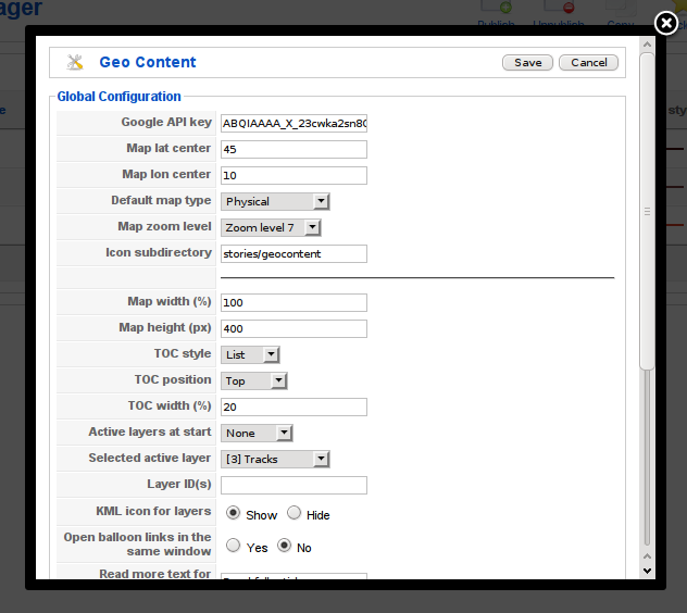
GeoContent main configuration is done through the “Parameters” button in the main GeoContent view (from Joomla! control panel, choose then click on the “Parameters” icon on the right).
Parameters
This section contains a detailed list of all configuration parameters and their meaning.
General parameters
This options are available in Main configuration window and Overview maps menu item configuration (see: Overview maps configuration).
| Label |
Name |
Notes |
Available in tag maps |
Available in front-end editor links |
|---|
| Google API key |
google_api_key |
The API key is different for every
domain on the internet and you can
obtain one for your website from
http://code.google.com/apis/maps/signup.html |
No |
No |
| Map lat center |
gmap_latstart |
Latitude of the map center |
Yes |
Yes |
| Map lon center |
gmap_lngstart |
Longitude of the map center |
Yes |
Yes |
| Default map type |
gmap_type |
Default map type (G_SATELLITE_MAP,
G_NORMAL_MAP, G_HYBRID_MAP,
G_PHYSICAL_MAP) |
Yes |
Yes |
| Map zoom level |
gmap_zoomstart |
Map zoom level at start |
Yes |
Yes |
| Icon folder |
point_icon_folder |
Icon’s subdirectory (under
directory images, so
stories/geocontent translates
to images/stories/geocontent) |
No |
No |
| Article’s ID |
contentid |
Show items for this particular Joomla! article |
Yes |
Yes |
Front-end map view parameters
This group of options affects the appearance of the map, its size, the presence and position of the Table of Contents and which layers are visible and automatically activated when the map is loaded. All of this options are available in Tag maps.
| Label |
Name |
Notes |
|---|
| Map width (%) |
map_width |
The width of the map wrapper DIV in percent |
| Map height (px) |
map_height |
The height of the map wrapper DIV in pixels |
| TOC style |
toc_style |
Style of the Table Of Contents (layers list):
* none: TOC is hidden
* list: TOC layer elements are drawn as list items
* select: TOC is drawn as a drop-down select |
| TOC position |
toc_position |
TOC position in respect to the map window within
the map wrapper DIV |
| TOC width (%) |
toc_width |
The width of the TOC frame (in %) when it is
positioned at the left or at the right of the map
frame. This option has no effect when toc_style
is top or bottom |
| KML icon |
toc_kml |
Shows in the Table of Contents a small globe icon with an
hyperlink to the KML file for the layers |
| Active layers at start |
start_with_layers |
Define which layer should be switched on at
startup. Choose ‘selected’ and pick one from
the list if you want to start with a
particular layer |
| Selected active layer |
active_layer |
Select here the layer that should be switched
on at startup if you choose ‘select’ as
start_with_layers parameter value |
| Open links in the same window |
replace_target |
Open balloon links in the same window.
Replace target = _blank in the map balloon
links, so that they are opened in the same window |
Front-end map edit parameters
This group of options affects front-end (the public side of Joomla!) editing functionality. For security reasons, none of this options are available in Tag maps.
| Label |
Name |
Notes |
|---|
| Front-end access |
front_end_enabled |
If the front-end users can edit/create maps.
This option completely enable/disable front-end
map editing |
| Minimum access level |
front_end_level |
Minimum user lever for front-end map handling |
| Check article’s user access |
front_end_check_user |
Additionally check if the user can edit the
article. Activate this option if you want to
prevent users to add/edit maps on articles they
have no editing permissions. This is an additional
internal check, that make only sense if the map
editing window is activated directly with a link,
the normal geocontent_editors-xtd plugin
behaviour is to add a button under the article’s
editor window, this means that Joomla!‘s standard
permission check is never overridden. |
| Unbound items |
front_end_unbound |
If enabled, it allows front end user to add map
items without linking to existing articles |
| Custom URLs allowed |
front_end_url |
Accepts arbitrary URLs for links in ballons when
created from the front end (can be a security
risk!) |
| Add only, no edit |
front_end_add_only |
If this option is enabled and front-end editing
is allowed, front-end users will only be allowed
to add new GeoContent Items and cannot edit existing ones |
| Article’s ID |
contentid |
Edit items for this particular Joomla! article |