QGIS Server With Python Superpowers
Workshop
Alessandro Pasotti
QCooperative / ItOpen

Workshop Program
- Introduction to QGIS Server
- General workflow
- Deployment strategies
- Server configuration
- QGIS Server vendor features
- Python development
- Python applications and embedding
- Python Plugins & Modules
- Access Control Plugins
- Cache Plugins
- Custom Services & APIs
QGIS Server
The WYSIWYG GIS Server
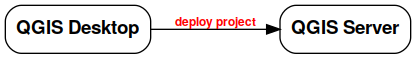
From the desktop to the web!
Typical Workflow

Supported Standards
- WMS 1.3
- WFS 1.0.0, 1.1.0
- WCS 1.1.1
- WMTS 1.0.0
- WFS3/OAPIF (new!)
System Overview

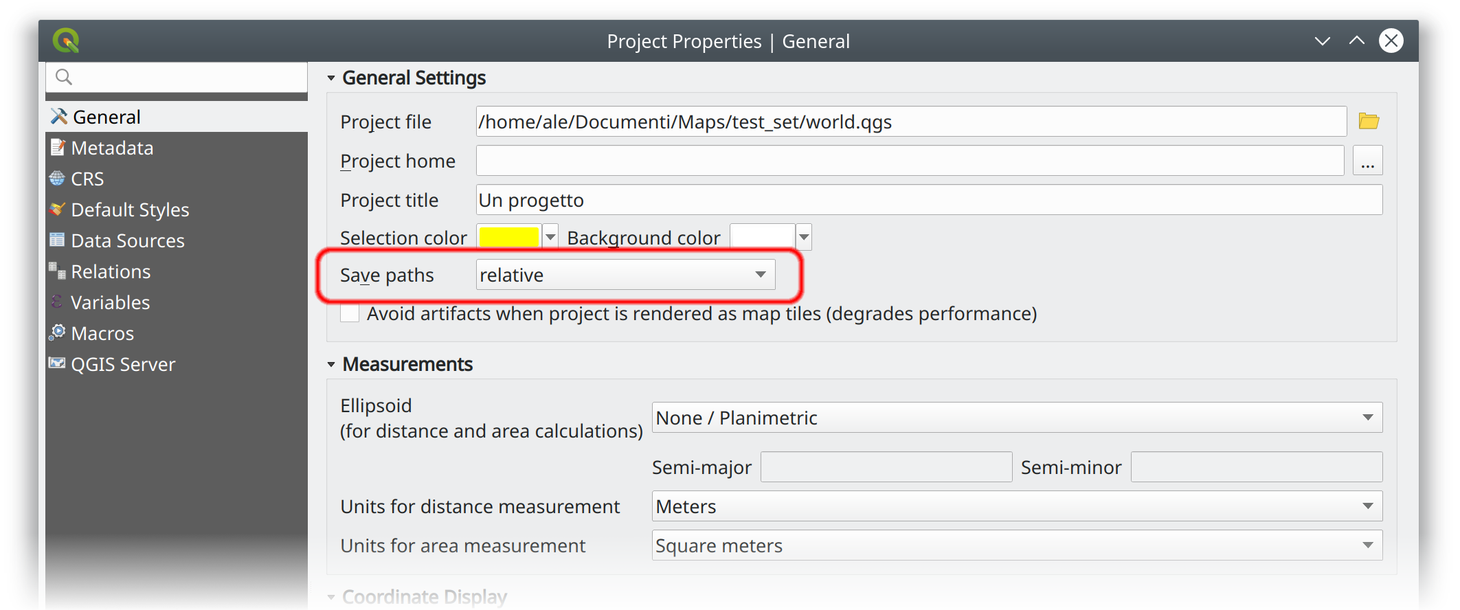
Project Configuration
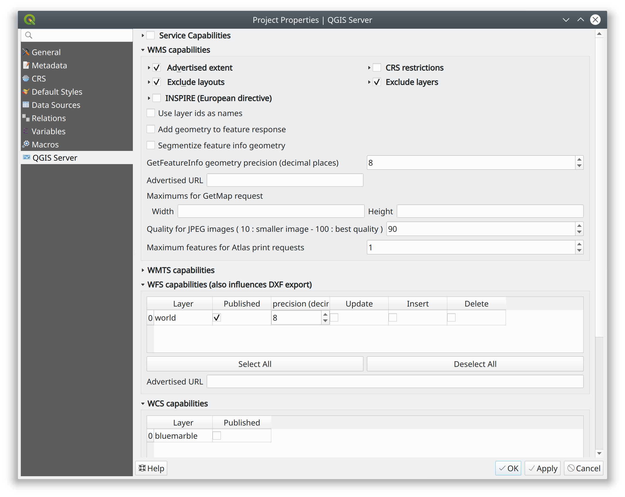
Official documentation: https://docs.qgis.org/testing/en/docs/user_manual/working_with_ogc/server/index.html
Data Storage
Project File Storage
- FILESYSTEM → MAP=/path/to/project.qgs or rewrite!
- DB → MAP=postgres://[user[:pass]@]host[:port]/?dbname=X&schema=Y&project=Z or rewrite!
Use rewrite!
Specifiers:
- first .QGS from binary directory
- MAP=
- environment variable QGIS_PROJECT_FILE
Deployment Strategies
1. Docker Containers
- - you have to know Docker
- + you can easily replicate/move/scale deployments
2. Bare Metal or VM
- + maybe easier to setup/customize
Docker Images

Demo VM Stack
Server | Port | Mapped to host |
Nginx FastCGI | 80 | 8080 |
Apache (Fast)CGI | 81 | 8081 |
Nginx Python | 82 | 8082 |
Nginx MapProxy | 83 | 8083 |
Development server | 8000 | 8000 |
Plain CGI is only useful for testing!
The Development Server
Not suitable for production!
Usage: qgis_mapserver [options] [address:port]
QGIS Development Server

Options:
-l <logLevel>     Sets log level (default: 0)
                    0: INFO
                    1: WARNING
                    2: CRITICAL
-p <projectPath>  Path to a QGIS project file (*.qgs or *.qgz),
                    if specified it will override the query string MAP argument
                    and the QGIS_PROJECT_FILE environment variable

Arguments:
addressAndPort    Listen to address and port (default: "localhost:8000")
                    address and port can also be specified with the environment
                    variables QGIS_SERVER_ADDRESS and QGIS_SERVER_PORT
FCGI Requirements Summary

xvfb is required for features like printing and HTML labels.
Advanced QGIS Server Configuration
12 factors app https://12factor.net/
Configuration through environment variables
- Paths to plugins, default project etc.
- Layers Authentication
- Parallel Rendering
- Logging
Authenticated Layers in QGIS Server
QGIS authentication DB qgis-auth.db path can be specified with the environment variable QGIS_AUTH_DB_DIR_PATH
QGIS_AUTH_PASSWORD_FILE environment variable can contain the master password required to decrypt the authentication DB.
Make sure that the permissions on the file are set to be only readable by the Server’s process user and check that the file is not accessible via any URL.
TODO for QGIS4: QGIS_AUTH_PASSWORD needs to be added.
Parallel Rendering
QGIS_SERVER_PARALLEL_RENDERING
Activates parallel rendering for WMS GetMap requests. It’s disabled (false) by default. Available values are:
0 or false (case insensitive) 1 or true (case insensitive)
QGIS_SERVER_MAX_THREADS
Number of threads to use when parallel rendering is activated. Default value is -1 to use the number of processor cores.
Logging
QGIS_SERVER_LOG_FILE (deprecated)
Specify path and filename. Make sure that server has proper permissions for writing to file. File should be created automatically, just send some requests to server. If it’s not there, check permissions.
QGIS_SERVER_LOG_STDERR (best option)
QGIS_SERVER_LOG_LEVEL
Specify desired log level. Available values are:
0 or INFO (log all requests) 1 or WARNING 2 or CRITICAL (log just critical errors, suitable for production purposes)
Caching
A QGIS Server instance caches:
- capabilities XML document
Caches are not shared among instances, layers are not cached.
Caching is generally delegated to different tier, caching solutions are expecially recommended for serving tiles:
- mapproxy https://mapproxy.org/
- tilecache http://tilecache.org/
- tilestache http://tilestache.org/
Look for metatiles and/or activate TILE buffer support if your layers contain labels.
WFS3/OAPIF and the new OGC APIs
Resources overrides (HTML templates, JS/CSS etc.):
Base directory for all WFS3 static resources (HTML templates, CSS, JS etc.) QGIS_SERVER_API_RESOURCES_DIRECTORY
VM Stack Summary


- xvfb (headless X server, required by QT)
- Apache2: web server
- mod_fcgid Apache module for FastCGI
Alternative:
- Nginx: web server
- systemd (Linux process manager, for FastCGI + nginx)
Optional:
- MapProxy: Python based WMS/WFS/TMS caching proxy
Bare Metal - OS Setup
We are using Ubuntu Bionic 64bit
https://github.com/elpaso/qgis3-server-vagrant
in Vagrant it is provided by the box:
https://cloud-images.ubuntu.com/bionic/current/bionic-server-cloudimg-amd64-vagrant.box
Setup Steps
- Add QGIS repositories
- Install support packages (Nginx, Apache etc.)
- Install QGIS server
- Configure services
- Start services
- Test services
Provided VMs
- Unprovisioned (software installed, no configuration)
You need to make the configuration manually or run the provisioning scripts from:
/vagrant/provisioning
- Fully provisioned (ready to run)
SSH into the Machine
Plain VM (username: qgis, password: qgis):
ssh -p 2222 qgis@localhost # password: qgis
sudo su - # become superuser
Vagrant:
vagrant up
vagrant ssh
sudo su - # become superuserCheckpoint: you need to be able to log into the machine and become root
Add Resources from Workshop Repository
Only for unprovisioned machines!
wget https://github.com/elpaso/qgis3-server-vagrant/archive/master.zip
unzip master.zip
rm -rf /vagrant/ # if exists
mv qgis3-server-vagrant-master/ /vagrant
rm master.zip
cd /vagrant/provisioning
The Provisioning Scripts
- config.sh (configuration)
- setup.sh (complete setup)
- download_only.sh (download only)
Steps:
- common.sh
- apache2.sh
- nginx.sh
- mapproxy.sh
Add Required Repositories
# Add QGIS repositories
apt-key adv --keyserver keyserver.ubuntu.com --recv-key 51F523511C7028C3
echo 'deb http://qgis.org/ubuntu-nightly bionic main' > /etc/apt/sources.list.d/ubuntu-qgis.list
apt-get update && apt-get -y upgrade
Which repository? https://qgis.org/en/site/forusers/alldownloads.html#debian-ubuntu
Check for New Packages
Checkpoint: the available version of qgis-server must be >= 3 from qgis.org
apt-cache policy qgis-server
# output follows:
qgis-server:
Installed: 1:3.11.0+git20200214+51ba7e8a89+28bionic
Candidate: 1:3.11.0+git20200214+51ba7e8a89+28bionic
Version table:
*** 1:3.11.0+git20200214+51ba7e8a89+28bionic 500
       500 http://qgis.org/ubuntu-nightly bionic/main amd64 Packages
       100 /var/lib/dpkg/status
    2.18.17+dfsg-1 500
       500 http://it.archive.ubuntu.com/ubuntu bionic/universe amd64 Packages
Install System Software
Install the software, see:
/vagrant/provisioning/config.sh
/vagrant/provisioning/common.sh
# Common configuration
export QGIS_SERVER_DIR=/qgis-server
export DEBIAN_FRONTEND=noninteractive
# Install QGIS server and deps (overwrite is a temporary solution)
apt-get -y install -o Dpkg::Options::="--force-overwrite" qgis-server python3-qgis xvfb
# Install utilities (optional)
apt-get -y install vim unzip ipython3
Install System Software I
Checkpoint: qgis installed with no errors, you can check it with
/usr/lib/cgi-bin/qgis_mapserv.fcgi 2> /dev/null
Content-Length: 54
Content-Type: text/xml; charset=utf-8
Server:  Qgis FCGI server - QGis version 3.0.0-Girona
Status:  500

<ServerException>Project file error</ServerException>
Install System Software II
Copy resources
. /vagrant/provisioning/config.sh

# Install sample projects and plugins
mkdir -p $QGIS_SERVER_DIR/logs
cp -r /vagrant/resources/web/htdocs $QGIS_SERVER_DIR
cp -r /vagrant/resources/web/plugins $QGIS_SERVER_DIR
cp -r /vagrant/resources/web/projects $QGIS_SERVER_DIR
chown -R www-data.www-data $QGIS_SERVER_DIR
Install System Software III
Setup xvfb and plain CGI
# Setup xvfb
cp /vagrant/resources/xvfb/xvfb.service \
    /etc/systemd/system/xvfb.service
systemctl enable /etc/systemd/system/xvfb.service
service xvfb start

# Symlink to cgi for apache CGI mode
ln -s /usr/lib/cgi-bin/qgis_mapserv.fcgi \
    /usr/lib/cgi-bin/qgis_mapserv.cgi
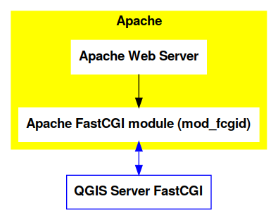
Apache2
Installation (with FCGI module)
The Apache HTTP Server Project is an effort to develop and maintain an open-source HTTP server for modern operating systems including UNIX and Windows.
apt-get -y install apache2 libapache2-mod-fcgid
Apache2 architecture
Apache2 Configuration I
Configure the web server
cp /vagrant/resources/apache2/001-qgis-server.conf \
    /etc/apache2/sites-available
# sed: replace QGIS_SERVER_DIR with actual path
sed -i -e "s@QGIS_SERVER_DIR@${QGIS_SERVER_DIR}@g" \
    /etc/apache2/sites-available/001-qgis-server.conf
# sed: replace port from 80 to 81
sed -i -e 's/VirtualHost \*:80/VirtualHost \*:81/' \
    /etc/apache2/sites-available/001-qgis-server.conf
sed -i -e "s@QGIS_SERVER_DIR@${QGIS_SERVER_DIR}@g" \
    $QGIS_SERVER_DIR/htdocs/index.html
Apache2 Configuration II
VirtualHost configuration for both FastCGI and CGI
<VirtualHost *:81>
    # [ ... ] Standard config goes here
    FcgidInitialEnv DISPLAY ":99"
    FcgidInitialEnv LC_ALL "en_US.UTF-8"
    # FcgidInitialEnv QGIS_DEBUG 1
    # FcgidInitialEnv QGIS_PLUGINPATH "QGIS_SERVER_DIR/plugins"
    # FcgidInitialEnv QGIS_AUTH_DB_DIR_PATH "QGIS_SERVER_DIR"
    # Path to the QGIS3.ini settings file
    # FcgidInitialEnv QGIS_OPTIONS_PATH "QGIS_SERVER_DIR"
    # Path to the user profile directory
    # FcgidInitialEnv QGIS_CUSTOM_CONFIG_PATH "QGIS_SERVER_DIR"
Apache2 Configuration III
Logging
# FcgidInitialEnv QGIS_DEBUG 1
# Deprecated log to file (bad practice!)
# FcgidInitialEnv QGIS_SERVER_LOG_FILE "QGIS_SERVER_DIR/logs/qgis-apache-001.log"
# Log to stderr instead:
FcgidInitialEnv QGIS_SERVER_LOG_STDERR 1
# FcgidInitialEnv QGIS_SERVER_LOG_LEVEL 0
Apache2 Configuration IV
    # Required by QGIS plugin HTTP BASIC auth
    <IfModule mod_fcgid.c>
        RewriteEngine on
        RewriteCond %{HTTP:Authorization} .
        RewriteRule .* - [E=HTTP_AUTHORIZATION:%{HTTP:Authorization}]
    </IfModule>
    ScriptAlias /cgi-bin/ /usr/lib/cgi-bin/
    <Directory "/usr/lib/cgi-bin">
        AllowOverride All
        Options +ExecCGI -MultiViews +FollowSymLinks
        Allow from all
        AddHandler cgi-script .cgi
        AddHandler fcgid-script .fcgi
        Require all granted
    </Directory>
</VirtualHost>
Apache2 Configuration V
Enable sites and restart
a2enmod rewrite # Only required by some plugins
# a2enmod cgid # Required by plain old CGI
a2dissite 000-default
a2ensite 001-qgis-server
# Listen on port 81 instead of 80 (nginx)
sed -i -e 's/Listen 80/Listen 81/' /etc/apache2/ports.conf
service apache2 restart # Restart the server
Checkpoint: check whether Apache is listening on localhost port 8081 http://localhost:8081
Nginx Installation
nginx [engine x] is an HTTP and reverse proxy server, a mail proxy server, and a generic TCP/UDP proxy server
# Install the software
export DEBIAN_FRONTEND=noninteractive
apt-get -y install nginx
Nginx architecture
Nginx configuration I
# Enable site
rm /etc/nginx/sites-enabled/default
cp /vagrant/resources/nginx/qgis-server-fcgi \
    /etc/nginx/sites-enabled/qgis-server
# sed: replace QGIS_SERVER_DIR with actual path
sed -i -e "s@QGIS_SERVER_DIR@${QGIS_SERVER_DIR}@" \
    /etc/nginx/sites-enabled/qgis-server
Nginx Configuration II
# Extract server name and port from HTTP_HOST, this
# is required because we are behind a VMs mapped port

map $http_host $parsed_server_name {
    default  $host;
    "~(?P<h>[^:]+):(?P<p>.*+)" $h;
}

map $http_host $parsed_server_port {
    default  $server_port;
    "~(?P<h>[^:]+):(?P<p>.*+)" $p;
}
Nginx Configuration III
Load balancing (round robin default, or least_conn;)
upstream qgis_mapserv_backend {
    ip_hash;
    server unix:/run/qgis_mapserv4.sock;
    server unix:/run/qgis_mapserv3.sock;
    server unix:/run/qgis_mapserv2.sock;
    server unix:/run/qgis_mapserv1.sock;
}
- Sessions and persistence (ip-hash)!
- Caching
Nginx Configuration IV
server {
    listen 80 default_server;
    listen [::]:80 default_server;

    # This is vital
    underscores_in_headers on;

    root /qgis-server/htdocs;

    location / {
            # First attempt to serve request as file, then
            # as directory, then fall back to displaying a 404.
            try_files $uri $uri/ =404;
    }
Nginx Configuration V
Rewrite!
# project file set by env var
# example: http://localhost:8080/project/project_base_name/
location ~ ^/project/([^/]+)/?(.*)$
{
  set $qgis_project /qgis-server/projects/$1.qgs;
  rewrite ^/project/(.*)$ /cgi-bin/qgis_mapserv.fcgi last;
}
Nginx Configuration VI
location /cgi-bin/ {
    # Disable gzip (it makes scripts feel slower since they
    # have to complete before getting gzipped)
    gzip off;

    # Fastcgi socket
    fastcgi_pass  qgis_mapserv_backend;

    # $http_host contains the original server name and port, such as: "localhost:8080"
    fastcgi_param SERVER_NAME       $parsed_server_name;
    fastcgi_param SERVER_PORT       $parsed_server_port;

    # [ continue ... ]
Nginx Configuration VII
        # [ ... continued ]

        # Set project file from env var
        fastcgi_param QGIS_PROJECT_FILE $qgis_project;

        # Fastcgi parameters, include the standard ones
        # (note: this needs to be last or it will overwrite fastcgi_param set above)
        include /etc/nginx/fastcgi_params;

    }
}
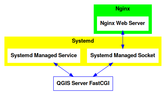
Systemd Socket Config for FastCGI
Socket
# Path: /etc/systemd/system/qgis-server-fcgi@.socket
# systemctl enable qgis-server-fcgi@{1..4}.socket && systemctl start qgis-server-fcgi@{1..4}.socket

[Unit]
Description = QGIS Server FastCGI Socket (instance %i)
[Socket]
SocketUser = www-data
SocketGroup = www-data
SocketMode = 0660
ListenStream = /run/qgis_mapserv%i.sock
[Install]
WantedBy = sockets.target
Systemd Service Config for FastCGI
# Path: /etc/systemd/system/qgis-server-fcgi@.service
# systemctl start qgis-server-fcgi@{1..4}.service

[Unit]
Description = QGIS Server Tracker FastCGI backend (instance %i)
[Service]
User = www-data
Group = www-data
ExecStart = /usr/lib/cgi-bin/qgis_mapserv.fcgi
StandardInput = socket
StandardOutput=syslog
StandardError=syslog
SyslogIdentifier=qgis-server-fcgi
WorkingDirectory=/tmp
Restart = always
Systemd Service Config for FastCGI
Service
# Environment
Environment="QGIS_AUTH_DB_DIR_PATH=QGIS_SERVER_DIR/projects"
Environment="QGIS_SERVER_LOG_FILE=QGIS_SERVER_DIR/logs/qgis-server-fcgi.log"
Environment="QGIS_SERVER_LOG_LEVEL=0"
Environment="QGIS_DEBUG=1"
Environment="DISPLAY=:99"
Environment="QGIS_PLUGINPATH=QGIS_SERVER_DIR/plugins"
Environment="QGIS_OPTIONS_PATH=QGIS_SERVER_DIR"
Environment="QGIS_CUSTOM_CONFIG_PATH=QGIS_SERVER_DIR"

[Install]
WantedBy = multi-user.target
Checkpoint: QGIS as a Client
Check WMS and WFS using QGIS as a client.
Check that WFS requires HTTP Basic auth (username and password = "qgis")
Check that WWS GetFeatureInfo returns a (blueish) formatted HTML
Note: a test project with pre-configured endpoints is available in the resources/qgis/ directory.
Checkpoint: WMS Search FILTER
Searching features with WMS
http://localhost:8080/cgi-bin/qgis_mapserv.fcgi?
MAP=/qgis-server/projects/helloworld.qgs&SERVICE=WMS
&REQUEST=GetFeatureInfo&CRS=EPSG%3A4326&WIDTH=1794&HEIGHT=1194
&LAYERS=world&QUERY_LAYERS=world&
FILTER=world%3A%22NAME%22%20%3D%20%27SPAIN%27
The filter is a QGIS Expression:
FILTER=world:"NAME" = 'SPAIN'
- Field name is enclosed in double quotes, literal string in single quotes
- You need exactly one space between the operator and tokens
WMS Vendor Parameters
Full list: https://docs.qgis.org/testing/en/docs/user_manual/working_with_ogc/server/services.html
- WITH_GEOMETRY (FALSE|TRUE)
- WITH_MAPTIPS (FALSE|TRUE)
http://localhost:8081/cgi-bin/qgis_mapserv.fcgi?
INFO_FORMAT=text/plain&MAP=/qgis-server/projects/helloworld.qgs
&SERVICE=WMS&REQUEST=GetFeatureInfo&CRS=EPSG%3A4326&WIDTH=1794&HEIGHT=1194&LAYERS=world&
WITH_GEOMETRY=TRUE&QUERY_LAYERS=world&FILTER=world%3A%22NAME%22%20%3D%20%27SPAIN%27
Checkpoint: Highlighting
The SELECTION parameter can highlight features from one or more layers: Vector features can be selected by passing comma separated lists with feature ids in GetMap and GetPrint. Example: SELECTION=mylayer1:3,6,9;mylayer2:1,5,6
http://localhost:8080/cgi-bin/qgis_mapserv.fcgi?
MAP=/qgis-server/projects/helloworld.qgs&SERVICE=WMS&VERSION=1.3.0&
SELECTION=world%3A44&REQUEST=GetMap&FORMAT=image%2Fpng&TRANSPARENT=true&
LAYERS=world&CRS=EPSG%3A4326&STYLES=&DPI=180&WIDTH=1794&HEIGHT=1194&
BBOX=31.7944%2C-18.2153%2C58.0297%2C21.20361
Checkpoint: Printing
From composer templates (with substitutions!)
<Layouts>
  <Layout units="mm" printResolution="300" name="Printable World"
  worldFileMap="{db75b0bf-f2f1-42e6-9727-1b6b21d8862e}">
  ...
FORMAT can be any of PDF, PNG, JPG
See also: DXF Export
Checkpoint: Printing URL
http://localhost:8080/cgi-bin/qgis_mapserv.fcgi?
MAP=/qgis-server/projects/helloworld.qgs&SERVICE=WMS&VERSION=1.1.1&
REQUEST=GetPrint&TEMPLATE=Printable%20World&CRS=EPSG%3A4326&
map0:EXTENT=4,52,14,58&FORMAT=png&LAYERS=bluemarble,world
Checkpoint: Printing Substitutions
- Assign an ID to the label
- add label_name=Your custom text
- as an ID, choose a word that is not reserved in WMS
http://localhost:8080/cgi-bin/qgis_mapserv.fcgi?
MAP=/qgis-server/projects/helloworld.qgs&SERVICE=WMS&
VERSION=1.1.1&REQUEST=GetPrint&TEMPLATE=Printable%20World
&CRS=EPSG%3A4326&map0:EXTENT=4,52,14,58&FORMAT=png
&LAYERS=bluemarble,world&print_title=Custom%20print%20title!
Python Development
QGIS Server and Python
What can we do?
- EMBEDDING → Use QGIS Server API from another Python application
- STANDALONE → Run QGIS Server as a WSGI/HTTP service
- FILTERS → Enhance/Customize QGIS Server with filter plugins
- SERVICES → Add a new SERVICE
- OGC APIs → Add a new OGC API
QGIS Server Modules
I/O Filters
Applications:
- web clients configuration
- authentication/authorization
- new services (WPS etc.)
- new output formats
- customization of standard services (ex: GetFeatureInfo)
Legacy Architecture
SERVICE modules
- WMS WFS WCS WMTS
- XML-based (JSON and other formats are available)
Customization
- Custom modules (C++ and Python)
- Python filter plugins (I/O, access control, cache)
New OGC API Architecture
OGC API modules
- WFS3/OAPIF API handler
- JSON / REST based
Customization
- Custom API handlers (C++ and Python)
- Python filter plugins (I/O, access control, cache)
Python Development Topics
- Standalone/Embedding
- Plugins Anatomy
- Filters
- I/O
- Access Control
- Cache
- Custom Services
- Custom OGC API handlers
QGIS Server API
For standalone or embedding:
- QgsServer() server instance
- QgsBufferServerRequest(url)
- QgsBufferServerResponse()
- QgsServer.handleRequest(request, response)
Python API Basics
from qgis.core import QgsApplication
from qgis.server import *
app = QgsApplication([], False)
server = QgsServer()
request = QgsBufferServerRequest(
    'http://localhost:8081/?MAP=/qgis-server/projects/helloworld.qgs' +
    '&SERVICE=WMS&REQUEST=GetCapabilities')
response = QgsBufferServerResponse()
server.handleRequest(request, response)
print(response.headers())
print(response.body().data().decode('utf8'))
app.exitQgis()
Full script: https://github.com/qgis/QGIS/blob/master/tests/src/python/qgis_wrapped_server.py
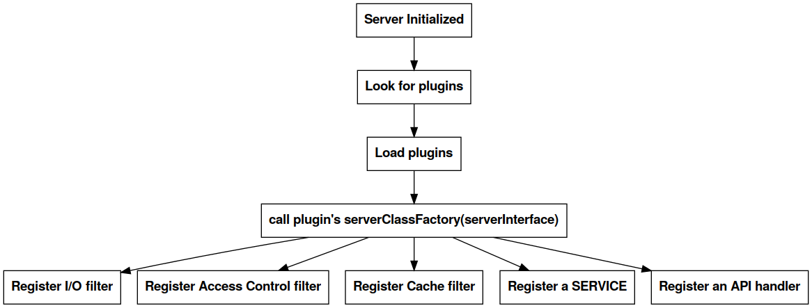
Plugins Anatomy
Plugins are loaded from QGIS_PLUGINPATH directory.
The Server Interface
A QgsServerInterface instance is made available to plugins and it provides methods to register filters, services and APIs and methods to manage the capabilities cache for legacy services.
Plugins Workflow
Filter Plugins Registration
Type | Base Class | QgsServerInterface registration |
I/O | QgsServerFilter | registerFilter() |
Access Control | QgsAccessControlFilter | registerAccessControl() |
Cache | QgsServerCacheFilter | registerServerCache() |
Note: custom SERVICE and API handlers are registered in the serverInterface.serviceRegistry()
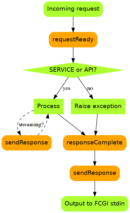
I/O Filters Hooks
Server plugins register one or more QgsServerFilters that "listen to signals". Plugin filters receive the request/response objects and they can manipulate them with the following methods:
- requestReady() → triggered after the request object is created
- responseComplete() → triggered after the main loop completes
- sendResponse() → triggered before response byte stream is sent to the client
I/O Filters Flowchart
I/O Filters Examples
Access Control Filter Plugins
Fine-grained control over layers, features and attributes!
- layerFilterExpression(layer)
- layerFilterSubsetString(layer)
- layerPermissions(layer) → QgsAccessControlFilter.LayerPermissions
- authorizedLayerAttributes(layer, attributes)
- allowToEdit(layer, feature)
- cacheKey()
Docs: https://docs.qgis.org/testing/en/docs/pyqgis_developer_cookbook/server.html#access-control-plugin
Cache Filter Plugins
from qgis.server import QgsServerCacheFilter
import hashlib

class StupidCache(QgsServerCacheFilter):
    """A simple in-memory and not-shared cache for demonstration purposes"""
    _cache = {}
    def _get_hash(self, request):
        # create a unique hash from the request
        paramMap = request.parameters()
        urlParam = "&".join(["%s=%s" % (k, paramMap[k]) for k in paramMap.keys()])
        m = hashlib.md5()
        m.update(urlParam.encode('utf8'))
        return m.hexdigest()
Cache Plugins II
    def getCachedDocument(self, project, request, key):
        hash = self._get_hash(request)
        try:
            result = self._cache[self._get_hash(request)]
            return result
        except KeyError:
            return QByteArray()

    def setCachedDocument(self, doc, project, request, key):
        hash = self._get_hash(request)
        self._cache[hash] = doc
        return True

serverIface.registerServerCache(StupidCache(serverIface), 100 )
Legacy Custom Services
New server plugin-based service architecture!
You can now create custom services in pure Python.
Example: https://github.com/elpaso/qgis3-server-vagrant/blob/master/resources/web/plugins/xyz/xyz.py
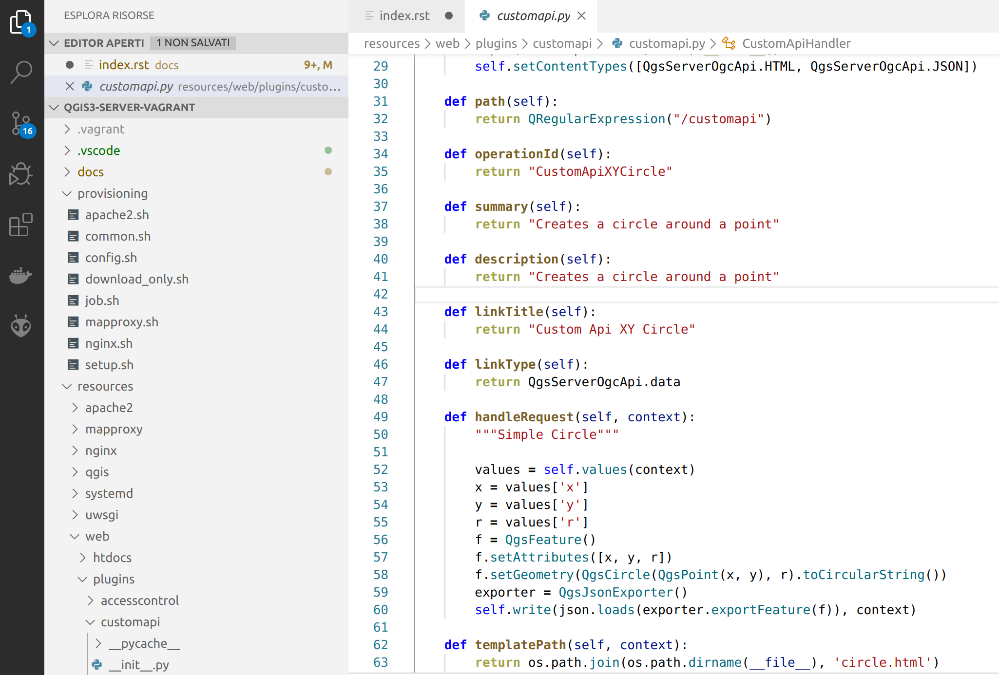
OGC API Custom Services
Since QGIS 3.10
New server plugin-based API architecture!
You can now create custom APIs in pure Python.
Other examples
The Python QGIS tests contain a comprehensive set of scripts to test services implementations in QGIS Server:
Release cycle
LTR: 12 months support
https://www.qgis.org/it/site/getinvolved/development/roadmap.html#release-schedule
Presentation links
https://github.com/elpaso/qgis3-server-vagrant/ (docs folder)